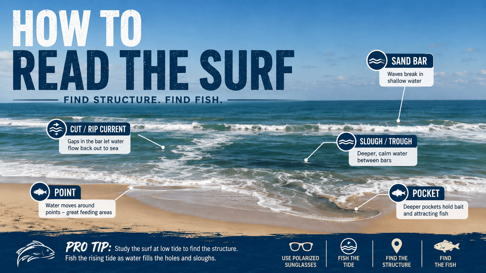
To the untrained eye, the Atlantic Ocean rolling onto the beaches of Topsail Island, North Carolina, looks like a uniform wall of crashing water. Beachgoers see waves and sand, but an experienced surf angler sees an intricate road map written in the foam. Learning how to “read the surf” is the single most critical skill that separates anglers who consistently bend rods from those who simply cast their bait into a barren aquatic desert.
Fish do not wander aimlessly in the ocean waves. They are lazy, highly efficient predators that utilize underwater terrain—sandbars, sloughs, cuts, and holes—to conceal themselves, conserve energy, and ambush prey. If you cast blind, you might get lucky. But if you learn to interpret the contours hidden beneath the surface, you can target feeding fish with surgical precision.
In this comprehensive guide, we will break down the fundamental physics of beach topography, identify the structural features every surf fisherman must look for, and explain how to apply these skills specifically across Topsail’s 26 miles of shoreline.
The Mechanics of Surf Structure: How Waves Reveal Terrain
Before stepping foot on the sand, you must understand a basic rule of coastal hydrodynamics: waves break over shallow water and reform or stall in deep water. By simply observing where waves break, roll, and dissipate, you can map the hidden ocean floor without needing underwater camera equipment or sonar.
As ocean swells travel toward the shore, they hit shallow sandbars. This sudden rise in the sea floor compresses the energy of the wave, forcing it upward until the top becomes unstable and spills over into white water (breaking). Once that broken wave crosses the shallow bar into a deeper trough (a slough), it loses energy, smooths out, and stops breaking—until it hits the shallow beach slope for its final shorebreak.
By studying the rhythm of breaking white water versus calm, dark green water, you can quickly identify the key features that attract fish.
The Big Four: Core Surf Features Every Angler Must Master
When you stand on the dunes looking out over the surf, you are scanning for four primary structural features. Each plays a distinct role in how bait moves and where predatory fish set up ambush zones.
1. Sandbars (The Feeding Shelves)
Sandbars are ridges of sand formed parallel or diagonal to the shoreline by wave action and currents. Typically, a beach will have an “inner bar” close to shore and an “outer bar” farther out.
- Visual Cue: A consistent, continuous line of crashing white water running parallel to the beach.
- Target Species: Spanish mackerel, bluefish, and kingfish (sea mullet) often feed right on the outer lip of the bar where crashing waves dislodge marine worms, mole crabs (sand fleas), and coquina clams.
2. Sloughs or Troughs (The Aquatic Highways)
A slough (pronounced “slew”) is the deeper channel of water running parallel to the beach, tucked safely between the shore and the outer sandbar. It acts as a primary highway for fish traveling up and down the coast.
- Visual Cue: A distinct strip of darker, calmer, non-breaking water flanked by white foam on the sandbar outside it and the shorebreak inside it.
- Target Species: Red drum, black drum, pompano, and flounder spend the vast majority of their time cruising inside sloughs, foraging for prey swept off the surrounding bars.
3. Cuts, Gaps, and Rip Currents (The Ambush Points)
As waves push thousands of gallons of ocean water over the outer sandbar into the slough, that trapped water has to find a way back out to sea. It escapes by carving deep channels or “gaps” straight through the sandbar. These outgoing drains are known as cuts, runnels, or rip currents.
- Visual Cue: Look for a gap or break in the continuous line of crashing waves on the outer bar. The water inside a cut will often look discolored, churning, or cloudy as outbound currents push sand and foam seaward.
- Target Species: Trophy red drum and large flounder love cuts. Predators sit in the quiet, deeper pocket at the mouth of a cut, waiting for the outgoing current to deliver dislodged baitfish and crabs directly into their mouths.
4. Points and Pockets (The Natural Funnels)
Beach shorelines are rarely a perfectly straight line. Waves and longshore currents create subtle “points” of sand that jut out toward the ocean and concave “pockets” (or bowls) carved into the beach face.
- Visual Cue: Scalloped shapes along the wet sand line. The point extends outward into the water, while the pocket creates a small, quiet cove.
- Target Species: Cast along the edges of sand points where water sweeps around the bend. Pompano and sea mullet frequently gather in the calm, deep bowls of shoreline pockets to vacuum up exposed sand fleas.
Local Focus: Reading the Beaches of Topsail Island, NC
Topsail Island presents a dynamic and constantly shifting surf environment. Unlike rocky coasts or hardened shorelines, Topsail’s fine-grain barrier island sand is constantly reshaped by seasonal nor’easters, tropical storms, and strong longshore currents. What looked like a deep hole last autumn might be a shallow flat by summer.
To read Topsail’s surf effectively, you must understand the distinct personality of the island’s three main geographic stretches.
North Topsail Beach: Dynamic Inlets and Deep Depressions
The northern end of the island, extending toward New River Inlet, features some of the most dramatic water shifts on Topsail. Because of the heavy volume of water rushing in and out of New River Inlet, the surf zone here undergoes aggressive erosion and reformation.
- Local Tip: Focus on the extreme north end near the inlet spit. Look for massive “scour holes” carved out where the river’s outflow collides with Atlantic ocean swells. These deep pockets are renowned for holding oversized bull red drum in the fall and large flounder in late summer.
- Watch For: Heavy current drift. You will often need heavier pyramid sinkers (4 to 6 oz) to hold bottom in these deep, fast-moving cuts.
Surf City: Classic Bar-and-Slough Formations
The central portion of Topsail Island, stretching through Surf City, offers textbook barrier island sandbar geography. Here, the beach slope is generally moderate, creating well-defined inner and outer sandbars with deep sloughs running alongside the beach access points.
- Local Tip: Take advantage of elevated vantage points. Before walking down to the sand, stand on top of the dune crossover boardwalks or the Surf City Ocean Pier. Looking down from above makes it infinitely easier to spot dark green sloughs and brown, discolored cuts in the bar.
- Tactics: Cast one rod into the deep trough (slough) with shrimp or cut bait for drum and black drum, and fire a second rod over the inner bar into the outer breaking edge for pompano and sea mullet.
South Topsail (Topsail Beach): Broad Flats and Rip Channels
Heading south toward New Topsail Inlet, the island widens out, and the beach gradient becomes noticeably gentler. At low tide, broad, flat sandbars are exposed, separated by narrow, deep sloughs.
- Local Tip: Target the high-tide windows around New Topsail Inlet’s sound-side bars and southern point. As water floods over the broad flats, sight-casting for redfish in the clear, shallow water becomes possible. On the ocean side, look for deep, narrow “outs” (cuts through the bar) where incoming swells funnel bait into the sound.
A Step-by-Step Strategy for Scouting the Surf
To maximize your time on the water, follow this proven scouting protocol whenever you fish Topsail Island:
- Scout at Dead Low Tide: The absolute best time to read the surf is during low slack tide. The underwater architecture is laid bare. Mark the locations of deep holes, cuts in the bar, and pockets in your phone or notebook.
- Fish the Rising Tide: As the tide comes in (flood tide), water fills those newly identified holes and sloughs. Fish will move out of the deep ocean and ride the rising water directly into the features you scouted hours earlier.
- Look for Color Changes: Deep water appears dark blue or dark green; shallow sandbars look light green, yellow, or white. Murky, muddy brown water extending seaward through a breaker line indicates an active cut pushing sand out.
- Polarized Sunglasses are Mandatory: Never head to the beach without a quality pair of polarized sunglasses (amber or copper lenses are ideal for coastal NC). They cut the harsh surface glare, allowing you to clearly see sandbar edges, depth changes, and cruising fish.
Charting Your Strategy
Mastering the ability to read the surf transforms the beach from a vast, intimidating ocean into a manageable, highly structured playing field. Next time you head out to the sands of Topsail Island, leave the rods in the rack for five minutes. Pause at the top of the dune crossover boardwalk, study the lines of foam from your elevated view, locate the gaps in the bars, and pick your target. By casting with intent into proven structure, your catches will skyrocket.
Stay Informed and Get Involved
North Carolina’s fisheries are constantly evolving as new research, public input, and management decisions shape future regulations. Whether you support the current flounder rules or believe changes are needed, staying informed is the best way to make your voice heard. The North Carolina Division of Marine Fisheries (NCDMF) provides fisheries research, stock assessments, proclamations, and recreational fishing information. The North Carolina Marine Fisheries Commission (MFC) establishes many of the policies and regulations governing coastal fisheries and regularly accepts public comment. The North Carolina Wildlife Resources Commission (NCWRC) oversees Inland and Joint Fishing Waters and publishes regulations affecting anglers across the state. We encourage every fisherman—whether recreational or commercial—to follow these agencies, review proposed rule changes, and participate in the public process. Well-informed anglers help build better fisheries for everyone.
Continue Exploring Topsail.Fish
Whether you’re planning your first trip to Topsail Island or you’ve been fishing these waters for years, Topsail.Fish brings together local fishing knowledge, current conditions, trusted charter captains, seasonal guides, and practical resources to help you make the most of your time on the water.
Follow Our Progress
Each month we publish a Topsail.Fish Monthly Report that shares how the website is growing, what anglers are searching for, how visitors are using the site, how they are connecting with local captains, and how participating businesses are gaining visibility. It’s our way of documenting the steady growth of the Greater Topsail Island fishing community.
🎣 Planning a trip to the NC coast? Before you book a boat down south, check out why Topsail vs. Wilmington fishing offers a better backwater experience. 🎣
Own a Fishing Charter Around Topsail Island?
Get your business in front of local anglers searching for fishing charters, guides, and inshore adventures on Topsail.Fish. Our directory listings are designed to help captains improve online visibility, increase bookings, and build a stronger local presence.
Professional listings start at just $12/month.