Navigating Topsail Island: A Beginner’s Guide to Buoys, Shallow Channels, and Boating Etiquette
Welcome to the area! When it comes to boating Topsail Island, the waters are breathtakingly beautiful, the fishing is world-class, and the channels are occasionally a lot shallower than they look. Navigating our local sounds, shifting tidal creeks, and the bustling Intracoastal Waterway (ICW) is an incredible experience, but it can quickly become highly stressful for visitors and new boaters who are unfamiliar with dynamic coastal waters.
Between shifting sandbars, confusing intersection navigation buoys, and heavy weekend traffic, a little local preparation goes a long way. Whether you are operating a rental pontoon boat, launching your own center console from the sound-side ramps, or paddling a kayak through the marshes, here is everything you need to know to safely navigate Topsail’s waters, protect your lower unit, and keep local boating courteous for everyone on the water.
Reading the Road Signs: Understanding Coastal Buoys
Inland lakes use a simple, static system of white and orange markers, but coastal waters like the sound side of Topsail rely strictly on the U.S. Aids to Navigation System (ATONS). This system accounts for tides, currents, and ocean access. Therefore, the absolute most important rule to memorize before you ever crank your engine or leave the dock is “Red, Right, Returning.”
The “Red, Right, Returning” Rule
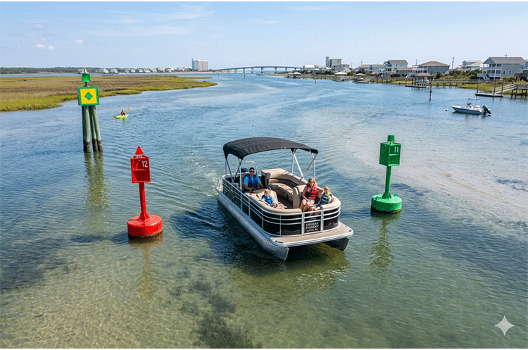
When you are traveling inbound from the ocean toward a port, or moving “upstream” away from the open sea into the sound, you must keep Red markers on your Right (starboard) side. Concurrently, Green markers stay on your Left (port) side. These markers will also feature numbers that help you track your position on a digital chartplotter; red markers use even numbers, and green markers use odd numbers. As you head out toward the ocean, the rule reverses: green will be on your right, and red on your left.
The ICW Twist: The Yellow Symbol Rule
Topsail Island is bordered directly by the Intracoastal Waterway (ICW), a massive marine highway running parallel to the Atlantic coast. On the ICW, boats aren’t just “returning” to a single local port—they are traveling long distances north and south along the entire eastern seaboard. To avoid complete chaos where local channels meet this highway, all navigational markers running along the ICW feature small, painted yellow geometric shapes:
- Yellow Triangle: Treat this like a Red marker. Keep it on your right (starboard) side when traveling south down the ICW (directionally toward Florida).
- Yellow Square: Treat this like a Green marker. Keep it on your left (port) side when traveling south down the ICW.
⚠️ Topsail Danger Zone: Where local inlets and creek channels intersect with the main ICW channel—such as the busy waters near the Surf City Bridge or passing by the New River Inlet—the physical markers can suddenly switch sides! Do not rely solely on the color of the piling. Always look for the yellow symbols painted directly on the signs to know which side of the channel you actually need to be on to avoid a hard grounding. For a full breakdown of these shapes, you can reference the official U.S. Coast Guard ATON Booklet.
Conquering Shallow Channels and Shifting Sandbars
Topsail Island’s backcountry sound waters are notorious for incredibly fast-shifting sands. Due to heavy winter storms and constant tidal rushes through New River Inlet and Topsail Inlet, a spot that had six feet of water last season might be a dry sandbar at low tide today. Consequently, proper hydrographic planning is essential for safe boating around Topsail Island.
1. Calculate Your Tidal Timing
Our local tides swing by three to over four feet twice a day. However, it is vital to understand that tide times vary significantly depending on where you are around the island. A high tide at the southern end of the island near Topsail Inlet can occur up to an hour or more before the high tide reaches the backwaters behind North Topsail Beach. A channel that is safely navigable at 1:00 PM might leave you completely hard aground on an oyster rock or mudflat by 4:00 PM. Always download a localized tide app and cross-reference your specific location before heading out.
2. Do Not Cut Corners Between Buoys
Sandbars naturally form on the inside curves of coastal channels where water velocity slows down, dropping sediment. When moving through winding sound channels, give the markers a wide, safe berth. Keep your vessel squarely in the middle of the channel line, even if it looks like you can save time by cutting a straight path across a bend.
3. Learn to Read the Color of the Water
Polarized sunglasses are an essential piece of safety gear for coastal boaters. They cut the water’s surface glare and allow you to read depth changes by color. Deep, safe water looks dark green, navy, or deep blue. Shallow sandbars and dangerous shoals look light green, yellow, or bright brown. Memorize the classic coastal adage: “Brown, brown, run aground; blue, blue, sail on through.” If the water ahead suddenly turns a pale tan, pull your throttle back to neutral immediately.
Boating Etiquette: Sharing the Water Safely
Topsail Island is a multi-use coastal paradise. On any given warm weekend, a single tidal creek might hold an inshore saltwater charter guide tracking redfish, a family pulling kids on a tube, three jet skis, and a dozen kayakers. Safe boating and accident prevention rely heavily on mutual respect and understanding the vessel hierarchy.
The Vessel Hierarchy and Right-of-Way
In maritime law, the less maneuverable a vessel is, the more right-of-way it possesses. This means motorized vessels must always yield to human-powered or wind-powered craft. Powerboats and personal watercraft (PWCs) must steer completely clear of sailboats under sail, commercial fishing charters actively working lines, kayaks, paddleboards, and canoes. If you are overtaking any of these vessels, it is your responsibility to execute the pass safely at a wide distance.
You Are Legally Responsible for Your Wake
This is the number one law of boating etiquette, and it is strictly legally binding in North Carolina. Boaters are civilly and legally responsible for any property damage or physical injury caused by the waves their boat creates (the wake). You can be held liable if your wake damages a vessel tied to a dock, capsizes a smaller skiff, or knocks an angler off their platform. Simply slowing down slightly is often not enough; a boat riding with its bow high in the air creates a massive, heavy “plow wake” that causes more damage than a boat running flat on plane.
Approaching Kayaks, Paddleboards, and Small Craft
Human-powered vessels always have the right-of-way in Topsail’s marshes. A large wake can easily flip a kayak or wash a paddleboarder dangerously into sharp oyster rocks or thick marsh grass.
- Slow Down Early: Do not zip past a kayak at full speed and expect your wake to calm down before it reaches them. Speed drops take time to dissipate.
- Drop to Idle Speed: Pull your throttle completely down to “No Wake” or “Idle Speed” (creating zero waves) when passing close to paddlers, or give them an incredibly wide berth if open water allows you to stay cleanly on a plane without throwing waves their way.
Approaching Stationary Fishing Boats
If you see an angler anchored, polling, or trolling near a marsh line, oyster rock, or deep creek hole, they are likely targeting skittish local species like Speckled Trout, Flounder, or Red Drum.
- Keep Your Distance: Avoid running directly through the shallow flat or narrow creek they are actively fishing. Your hull and propeller noise will instantly spook the school, ruining their fishing trip.
- Pass Quietly: If you must pass them in a narrow creek, drop your RPMs down to a quiet idle so your engine noise and hull slap do not disrupt their presentation or drift lines.
Quick Checklist for Your Topsail Island Boating Trip
- Check the Marine Weather: Summer afternoon thunderstorms can pop up instantly over the sound side, bringing dangerous lightning and sudden 30-knot wind gusts. Check the radar frequently.
- Verify USCG Safety Gear: You must have one wearable, properly fitted USCG-approved life jacket for every single person on board, plus a throwable cushion device. Children under 13 must wear their life jackets at all times while underway.
- File a Simple Float Plan: Cell phone service can become surprisingly spotty deep inside the coastal marshes behind Topsail. Always let someone back on land know exactly which boat ramp you launched from, where you plan to explore, and what time you expect to safely return.
By mastering the local buoys, keeping a constant eye on the changing tides, and treating your fellow anglers and boaters with respect, you will ensure a safe, memorable, and highly successful day of boating Topsail Island‘s gorgeous coastal waters!
Keep Building Your Topsail Fishing Skills
Want to put this technique to work on your next trip? Use these Topsail.Fish resources to check current fishing activity, match your tactics to the season, review local conditions, and find more step-by-step fishing guides.
🎣 Planning a fishing trip to coastal North Carolina? Before choosing a charter destination, discover why many anglers prefer Topsail Island’s less crowded waters, productive back bays, and outstanding inshore and surf fishing opportunities.
🎣 Planning a trip to the NC coast? Before you book a boat down south, check out why Topsail vs. Wilmington fishing offers a better backwater experience. 🎣

Are you a Topsail Area Captain?
Grow your charter business with an SEO-optimized listing in our directory. For just $12/month, we help you reach more anglers and secure the consistent bookings you need to thrive.